
 Continue with onX Maps
 Continue with Facebook


 Difficult

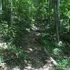
“Pole Cat descends approximately 500' over a half mile from Middle Ridge Road to County Route 23/15 (Shooting Range Rd.). ”


0.5
Miles0.8
KMSingletrack
 Difficult
Land Manager: West Virginia State Parks
 Kanawha State Forest Singletrack Highlights Ride
17.1 mi 27.5 km • 2,021' Up 616.03 m Up • 2,021' Down 615.96 m Down


 Scott's 5-Mile Training Loop
5.4 mi 8.7 km • 404' Up 123.05 m Up • 406' Down 123.6 m Down
 Quick Six
7.2 mi 11.7 km • 636' Up 193.87 m Up • 636' Down 194 m Down
Young Run-Stonestreetz-Kudlak's Kut Loop
2.6 mi 4.2 km • 339' Up 103.41 m Up • 357' Down 108.93 m Down
 The Bowl - Tol Flow Loops
1.9 mi 3.1 km • 154' Up 46.79 m Up • 154' Down 46.84 m Down
Eleanor City Park Trail
18.1 mi 29.1 km • 1,105' Up 336.69 m Up • 1,104' Down 336.54 m Down
Eleanor, WV


0 Comments