
 Continue with onX Maps
 Continue with Facebook


 Intermediate

“A 12+ mile gravel grind from Laurel Valley parking area down to Jocassee Dam. ”


12.6
Miles20.2
KMDoubletrack
 Intermediate
Land Manager: SC DNR - Jocassee Gorges
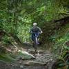
 Pisgah Stage Race - Stage 5
28.5 mi 45.8 km • 2,863' Up 872.78 m Up • 2,780' Down 847.39 m Down
 Brevard, NC
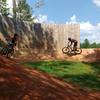
 Town Creek Bike Park
0.8 mi 1.3 km • 29' Up 8.75 m Up • 29' Down 8.76 m Down
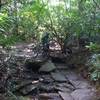
 Gravel Grind to Farlow Gap Loop
11.3 mi 18.3 km • 2,346' Up 715.02 m Up • 2,345' Down 714.84 m Down
 Brevard, NC
Black Mountain Loop
Brevard, NC
Black Mountain Loop
13.7 mi 22.0 km • 2,147' Up 654.34 m Up • 2,106' Down 642.04 m Down
Brevard, NC
 Pisgah 111K
72.1 mi 116.0 km • 8,909' Up 2715.32 m Up • 8,903' Down 2713.64 m Down
Brevard, NC
Pisgah Stage Race - Stage 2
30.3 mi 48.7 km • 4,082' Up 1244.27 m Up • 4,081' Down 1243.92 m Down
Brevard, NC


1 Comment