Dogs Unknown

E-Bikes
Unknown
Overview
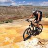
This loop combines quality dirt roads and fun flowy singletrack high up on the Chivato Plateau. The Chivato Plateau is high ground southwest of Cabezon Peak. The Continental Divide Trail (CDT) travels through this area.
This loop is a great way to check out the CDT - a mellow dirt road leads to the trail which is technical and rocky in some parts, but overall fun and flowy and mostly downhill trending.
Need to Know
The final climb on the road up to the Chivato Plateau can be a bit rough for 2x4 vehicles. If you find this to be the case, there is parking at the base of the hill, and it's not too far to ride up to the top. There are some sections of the CDT that the BLM does not allow riders; we saw a truck with US Forest Service decals that pointed us to the trail, so this section seems good to go for mountain biking. Watch out for hungry hikers! Lots of folks these day through-hike the CDT from the Mexican border to the Canadian Border.
Description
To get to the trailhead, follow
BLM 1103 to the top of the Chivato Plateau - park near the wooden fence next to Ned's Tank (signed). Warm up riding on the mellow, scenic and fun
BLM 1103 headed southwest. At about 5.6 miles from the parking, take the less travelled dirt road (still 1103). Follow this until the distant downhill, then you'll see a gate and trail markers for the
Continental Divide Trail (CDT): Chivato Plateau.
Just after the fence, the trail climbs in the trees, following a rocky trail that is easy to follow. There may be some hike-a-bike in here. Note that there are great cairns and CDT trail markers along this section of trail.
During the singletrack, most of it follows fun and pretty eassy, flowy and fast trail. There are a couple rocky hills, and a valley where the trail sidehills and is rocky again, but for the most part it’s fun and mellow.
When you get to the east edge of the plateau, the CDT descends to the valley floor - you don’t want to go that way to get back to Ned’s Tank. If you venture east and stay up on the plateau, you can check out the view, then you can backtrack to be on the loop trail (using the
Connector). Note this trail is braided and can be a little hard to follow since it has left the CDT.
Follow cattle singletrack and the
MTB Project mobile app to drop down to the road and trailhead; if in doubt, follow the edge of the plateau south and you'll intersect with
BLM 1103.
Contacts
Shared By:
Sarah Councell

 Continue with onX Maps
 Continue with Facebook


 Intermediate/Difficult


0 Comments