Use onX Backcountry to explore the terrain in 3D, view recent satellite imagery, and more.
Now available in onX Backcountry Mobile apps!
For more information see this post.
Be careful on the bridge when it is wet...it's slippery
Description
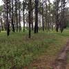
Canebrake starts near the beginning of Ravines West by veering to the right at the signs. The first part is open pine forest and flat. Then you come to the main intersection and you can go three different ways.
To the left is the top left of the figure 8 and it is rough and chewed up by hog infestation. To the right starts the lower loop of the 8 and straight across a small bridge takes you to the upper right loop, Live Oak trail loop and the connector back out to the Ravines West.
The southern loop of the 8 is hilly and in good shape. The upper loop is really chewed up by erosion and hogs.
Moderately steep. Uneven terrain with small rocks or roots.
Sizable rocks & roots. Steep sections.
Steep. Some technical terrain and limited alternate lines.
Very steep. Technical terrain with no alternate lines.
Difficulty Rating
Average from 1 vote:
Intermediate
Your Rating
Virtual Tour of Canebrake
We use cookies to improve your browsing experience, to show you
personalized content, and for statistical purposes. By continuing
to navigate our website, you accept our use of cookies. Read our
Privacy Policy to learn more.

 Continue with onX Maps
 Continue with Facebook


 Intermediate


0 Comments