
 Continue with onX Maps
 Sign in with Facebook


 Intermediate

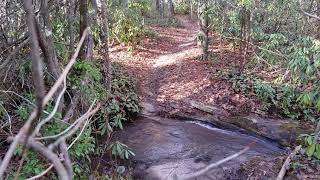
“A mellow, wide singletrack trail that connects Lake Imaging parking lot to the Hooker Falls parking lot. ”


1.1
Miles1.8
KMSingletrack
 Intermediate
Local Club: Pisgah Area SORBA
Land Manager: North Carolina Forest Service - Dupont State Forest
 Quick Ridgeline Route
4.9 mi 7.9 km • 582' Up 177.25 m Up • 583' Down 177.8 m Down

 Brevard, NC
 The Best of Dupont: Burnt Mtn. / Cedar Rock Big Rock Figure-Eight
6.3 mi 10.1 km • 773' Up 235.55 m Up • 772' Down 235.17 m Down
Brevard, NC
Pisgah Stage Race - Stage 5
28.5 mi 45.8 km • 2,863' Up 872.78 m Up • 2,780' Down 847.39 m Down
Brevard, NC
 Pisgah 111K
72.1 mi 116.0 km • 8,909' Up 2715.32 m Up • 8,903' Down 2713.64 m Down
Brevard, NC
Clawhammer Crawl
35.4 mi 56.9 km • 5,461' Up 1664.41 m Up • 5,517' Down 1681.61 m Down
Brevard, NC
Cove Creek Loop
10.0 mi 16.0 km • 985' Up 300.16 m Up • 986' Down 300.58 m Down
Brevard, NC


0 Comments