
 Continue with onX Maps
 Continue with Facebook


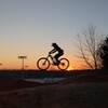
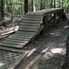
 Intermediate/Difficult

“The newest addition to Harrisburg Park, this trail has three creek crossings and a few punchy climbs. ”


1.5
Miles2.3
KMSingletrack
 Intermediate/Difficult
Local Club: Tarheel Trailblazers
Land Manager: Mecklenburg County - Park and Recreation
 Harrisburg Municipal Park
3.0 mi 4.9 km • 224' Up 68.31 m Up • 232' Down 70.73 m Down


 Fisher Farm Full Loop
4.3 mi 6.9 km • 291' Up 88.66 m Up • 292' Down 88.9 m Down
 Cedar Valley Bike Park
1.5 mi 2.5 km • 147' Up 44.66 m Up • 147' Down 44.7 m Down
Davidson, NC
Beatty's Black & Blue
5.9 mi 9.5 km • 217' Up 66.05 m Up • 218' Down 66.3 m Down
Back Yard Trails (BYT)
16.8 mi 27.0 km • 743' Up 226.36 m Up • 750' Down 228.59 m Down
Charlotte, NC
Anne Springs Close Greenway
8.6 mi 13.9 km • 635' Up 193.62 m Up • 632' Down 192.78 m Down
Fort Mill, SC


 Bad / Closed


0 Comments