
 Continue with onX Maps
 Continue with Facebook


 Intermediate/Difficult

“The climb goes on forever and the party never ends. ”


5.7
Miles9.2
KMSingletrack
 Intermediate/Difficult
Local Club: Evergreen Mountain Bike Alliance
Land Manager: WA DNR
 Raging River Loop
20.4 mi 32.9 km • 4,156' Up 1266.73 m Up • 4,156' Down 1266.6 m Down
 Snoqualmie, WA
 Crazy Ivan
1.4 mi 2.3 km • 88' Up 26.72 m Up • 684' Down 208.62 m Down
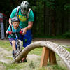
Duthie Hill Intro Lap
5.7 mi 9.2 km • 488' Up 148.78 m Up • 488' Down 148.64 m Down
City of…, WA
Soaring Eagle Outer Loop
5.3 mi 8.6 km • 410' Up 125.07 m Up • 410' Down 125.04 m Down
The Mana Loop
9.2 mi 14.9 km • 655' Up 199.67 m Up • 656' Down 199.9 m Down
Thrilla in Woodinvilla
17.8 mi 28.7 km • 1,369' Up 417.2 m Up • 1,372' Down 418.11 m Down


1 Comment