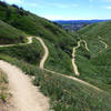
“Part of the bike path around Lake Perris on the west side of the lake. ”
3.0
Miles4.9
KMPaved Path

 Crafton Hills
9.9 mi 16.0 km • 1,369' Up 417.34 m Up • 1,367' Down 416.75 m Down


 Yucaipa, CA
 Loch Leven Loop
21.2 mi 34.1 km • 3,012' Up 918.12 m Up • 3,012' Down 917.99 m Down


 Yucaipa, CA
 Southridge XC Course
5.8 mi 9.3 km • 710' Up 216.56 m Up • 708' Down 215.71 m Down


 Glen Avon, CA
 Rim Nordic XC
8.7 mi 13.9 km • 1,034' Up 315.09 m Up • 1,043' Down 317.84 m Down


 Running…, CA
 NICA SoCal HS Cycling League: Vail Lake Challenge Race Course
5.7 mi 9.2 km • 459' Up 139.94 m Up • 465' Down 141.75 m Down


 Temecula, CA
 San Juan Lollipop
21.8 mi 35.1 km • 3,344' Up 1019.38 m Up • 3,344' Down 1019.13 m Down


 Coto De…, CA


0 Comments