
 Continue with onX Maps
 Continue with Facebook


 Intermediate

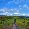
“An old forest road that makes a useful connection to trails. ”


4.3
Miles7.0
KMDoubletrack
 Intermediate
Land Manager: USFS - George Washington & Jefferson National Forests
 Bear Creek to Crawfish Ride
13.2 mi 21.3 km • 838' Up 255.56 m Up • 843' Down 256.8 m Down

 Mount Rogers
13.9 mi 22.3 km • 1,470' Up 447.98 m Up • 1,468' Down 447.49 m Down
 Rush Creek Loop
13.7 mi 22.0 km • 2,461' Up 750.01 m Up • 2,451' Down 747.12 m Down
 Chilhowie, VA
Bikepacking Pulaski to Damascus
Chilhowie, VA
Bikepacking Pulaski to Damascus
122.9 mi 197.8 km • 9,173' Up 2795.81 m Up • 9,179' Down 2797.78 m Down
Iron Mountain Out-and-Back
25.7 mi 41.4 km • 3,717' Up 1132.93 m Up • 3,719' Down 1133.52 m Down
 Virginia Creeper Trail - Damascus to Whitetop
18.2 mi 29.3 km • 2,039' Up 621.4 m Up • 403' Down 122.92 m Down
Glade S…, VA


0 Comments