Dogs Unknown

E-Bikes
Not Allowed
Need to Know
Although wildly popular, and close to town, this trail is not an official Forest trail. Due to vocal pressure from residents in the bordering neighborhood, the Talpa Traverse is in danger of being closed to mountain bikes when it is eventually incorporated as an official trail. Please ride in control and be aware of—and excessively courteous to—other users.
There are two access points for this trail - from the El Nogal trailhead ride up the South Boundary Trail and take the
South Boundary Connector #164B, or at an established parking area on NM Hwy 585 a few hundred feet east of Weimer Road is a common access point to the
Ojitos Trail #166.
Description
At times rideable during winter, and one of the first trails to dry out during spring the Talpa Traverse branches off of the
Ojitos Trail #166 about a half mile southeast from the junction with the
South Boundary Connector #164B. It can be easily missed, look for a narrow singletrack on the right dropping into an arroyo.
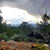
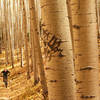
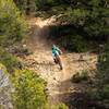
With a handful of moderately technical features mixed in with dozens of tight, bermed curves, this trail is overall pretty rocky yet has enough smooth and flowy sections to keep the stoke level high. Following a general downhill trend winding south through arid pinon and juniper forests it has plenty of short uphill pitches to keep your cranks spinning. It's a great trail to test ride a new bike, or work on your shifting and dropper-post skills.
The last mile has several well-worn side trails branching off the downhill side, most of these lead off of National Forest land into neighborhoods and are best to avoid but could be used for early exits in an emergency situation. When you see these trails, generally stay to the left and follow the dozens of rock cairns on either side of the trail until it ends at an atv road by some utility lines. You can follow the power lines a short ways down to Maestas road and ride through Talpa back towards Taos proper, or turn around and ride the trail back up to whichever trailhead you started at.
Shared By:
MTB Project Staff
with improvements
by J. Bella
and 2 others

 Continue with onX Maps
 Continue with Facebook


 Intermediate/Difficult


1 Comment