
 Continue with onX Maps
 Continue with Facebook


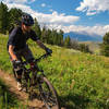
 Intermediate

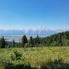
“A flowy Rick's Basin singletrack. ”


4.1
Miles6.6
KMSingletrack
 Intermediate
Land Manager: USFS - Caribou & Targhee National Forests Office
 Mill Creek/Colter's Escape
9.6 mi 15.4 km • 1,610' Up 490.71 m Up • 1,609' Down 490.32 m Down

 Moose W…, WY
 Canyon Creek Loop
23.9 mi 38.4 km • 4,559' Up 1389.55 m Up • 4,559' Down 1389.59 m Down
Phillips' Ridge to Phillip's Canyon via Sno-tel
15.0 mi 24.2 km • 2,304' Up 702.12 m Up • 2,304' Down 702.16 m Down
Moose W…, WY
Shadow Mountain Loop
7.4 mi 12.0 km • 1,422' Up 433.37 m Up • 1,428' Down 435.21 m Down
Jackson, WY
Red Creek loop
9.6 mi 15.5 km • 1,596' Up 486.55 m Up • 1,589' Down 484.36 m Down
Game Creek Loop
18.7 mi 30.1 km • 2,389' Up 728.05 m Up • 2,393' Down 729.34 m Down
Jackson, WY


0 Comments