Dogs Unknown

E-Bikes
Unknown
Description
This trail connects the USFS trailhead (Grouse Mountain) to the BLM picnic area and trailhead at Mosier Gulch (connects to the
Clear Creek Trail), via a long, continuous descent with many switchbacks.
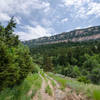
At the top, watch for where the signed singletrack trail diverges from doubletrack and begins its descent. The top portion is mostly open, with a few quick ducks into aspen forests and small rivulet crossings. Watch for a fence/gate part way down (requires you to dismount to get your bike through) and continue. The lower portion is mostly in the coniferous woods and has many very steep/tight switchbacks.
The trail exits the woods near the dam/spillway. Take the gravel road northeast (left) to the Mosier Gulch day-use area.
It's a two-way trail, but climbing is very difficult due to steep, tight switchbacks.
Contacts
Shared By:
Matt Goodman

 Continue with onX Maps
 Continue with Facebook


 Difficult


2 Comments