Use onX Backcountry to explore the terrain in 3D, view recent satellite imagery, and more.
Now available in onX Backcountry Mobile apps!
For more information see this post.
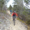
“A gentle ride with a few ups and downs through bush and some more open spaces along the coast.
”
From above Mistletoe Bay, follow the gently climbing track up for a while. After a bit, this will turn into a nice, cruisy ride. There are a few short inclines after you come down to the waterline, just before arriving in Anakiwa. This is a very relaxed ride that's the perfect cool-down along the final section of the QCT before take the road or boat back to Picton.
The Queen Charlotte Track is a multi-use trail that travels over DOC and private land. The trail is typically completed over multiple days. To learn about access, accommodations, and useful information check out this brochure, here.
Moderately steep. Uneven terrain with small rocks or roots.
Sizable rocks & roots. Steep sections.
Steep. Some technical terrain and limited alternate lines.
Very steep. Technical terrain with no alternate lines.
Difficulty Rating
Average from 2 votes:
Intermediate
Your Rating
Virtual Tour of Queen Charlotte Track: Mistletoe Bay to Anakiwa
We use cookies to improve your browsing experience, to show you
personalized content, and for statistical purposes. By continuing
to navigate our website, you accept our use of cookies. Read our
Privacy Policy to learn more.
0 Comments