Dogs Leashed

E-Bikes
Unknown
Overview
This ride has a little of everything. There are a lot of short climbs/descents that are surprisingly steep and one climb in particular that is extremely rocky and steep that will challenge most riders. A dozen or so creek crossings will probably give you wet feet although most can be ridden.
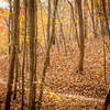
Most of the trail is flowing singletrack, but there are some short forest road sections. Most of the route is through dense forest offering shade from the hot summer sun. There are a number of historical markers that explain the history in this area.
This trail system never seems busy so you may have the place to yourself, but it is popular with equestrians, so keep a look out for four-legged friends.
Need to Know
There is no closure of this area, but the area is in the Lake Russell Wildlife Management Area and is subject to the restricted hunting season for the area. Consult the hunting schedule at the Georgia DNR site
here.
You'll need $5 for the parking/use fee (or your Interagency Annual Pass).
Description
Start off along the
Frady Branch Parking Spur Trail #234A. Follow the forest road until it dead ends into the
Frady Branch Loop Trail #234 singletrack, keeping to the right at two intersections. Continuing straight onto the singletrack into the woods, you'll enjoy about a mile of singletrack that twists in-and-out, up-and-down parralleling (and crossing several times) Frady Branch Creek.
At about 2.3 miles after the last (and one of the more difficult) creek crossings, you'll begin a very rocky (loose of course), steep, 300-foot climb. Needless to say, it's a difficult climb and you should be happy if you clean it. At the end of this singletrack, turn left onto
Pear Orchard Forest Road FS62B.
Follow
Pear Orchard Forest Road FS62B for about 0.4 miles. Then take a sharp right onto the
Latham Cemetery Trail #234D. If you reach a forest road intersection about 500 ft later, go back as you've missed the turn. Latham Forest Road FS87C is a flowing singletrack. After about 0.4 mi, you'll cross another creek and then begin a climb. Here you'll get acquainted with some Georgia red clay. At the end of this climb, you can enjoy the short descent back to another forest road. Turn left onto the forest road to follow the Latham Cemetery Loop.
After one mile on this forest road, you'll reach a three-way intersection. Continue straight onto the
Pear Orchard Trail #234C which is at first an old road bed. This passes through pine forest, so you can expect the ground to be covered in pine straw. This continues downhill until you reach the Mary Steele Waterfall where this is another water crossing. After another 0.3 miles you reach another, larger water crossing over Big Leatherwood Creek. If you want more mileage, just before the creek, you can take Latham Forest Road FS87C towards the other singletracks near Lake Russell and Nancy Town Lake.
Continuing on this loop across the creek, you'll climb on
Pear Orchard Trail #234C about 0.5 miles until you veer right to enter the
Frady Branch Loop Trail #234 singletrack. Thus begins an awesome 1/2 mile, narrow singletrack descent through hardwood forest. This ends all too quickly at a forest road; turn right to go back towards the parking lot.
After 0.5 miles, turn right onto
Leatherwood Creek Trail #234B.
This trail was rerouted in 2016, so older maps and descriptions might not be updated. This description and GPS reflects the new route.
Initially this is a forest road, but after about one mile, the road dead-ends at a clearing and it becomes a singletrack at the other end of the clearing. This begins the longest continuous climb on the route; you'll gain about 300 ft in the next mile, but there is only one short section that is particularly steep to contend with. You may have a decent view of the countryside when the leaves are down, but the tree cover is pretty heavy.
At the end of the
Leatherwood Creek Trail #234B, continue straight for about 500 ft and then veer right to take another ride on the fun downhill section of
Frady Branch Loop Trail #234 since it was too short the first time. Turn right at the bottom onto the forest road, and if you've had enough, take the
Frady Branch Parking Spur Trail #234A back to your car.
This is definitely one of those loops that you should ride in reverse as well as some of the key features will obviously be very different in the opposite direction.
History & Background
The land comprising Lake Russell Wildlife Management Area was acquired by the federal government in the late 1930's who bought the land from the farmers that owned it (sometimes using condemnation proceedings).
During World War II, the area was used for training paratroopers and the famed Camp Taccoa is nearby, although only one building remains. Important historical sites are marked throughout the trail with markers that explain this history.
Contacts
Shared By:
Lost Justpastnowhere

 Continue with onX Maps
 Continue with Facebook


 Intermediate/Difficult

 Lake Russell - Nancytown Loop


 Chicopee Woods Intermediate Loop


2 Comments