This trail has an official trailhead at 36°49'34"N 107°56'46"W. There is ample parking and maps of the area.
Mountain View is pleasant desert singletrack, sort of an
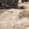
Alien Run with less topography. It is well worth a ride. It can be a bit sandy, so the riding after precipitation is good.
From 550, turn onto NM173, go about a mile, then bear right onto Old Spanish Trail and go to where it ends. Turn left and park at Tiger Park by the fishing ponds. The park is open from 5 am to midnight, with no overnight parking. You may also be able to park up near the Kart Track, off the north side of 173.
The trail takes off from the northeast corner of the lot, where there is an Aztec Trails and Open Space (ATOS) cairn: a basket of rocks. You'll see a number of these along the trail.
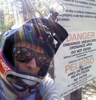
The first part of the trail has a strong gas well aesthetic, but gets you out to the singletrack on BLM land. You're going to experience some hydrocarbon production and consumption. There are faded arrows on white signs, but not too many so use the
MTB Project mobile app to stay on track.
The trail crosses NM173 then goes around the right side of the Kart Track (throttle stomping) and then the left side of the motocross track (throttle twisting). At this point, you'll see a bicycle on a tall pole. This landmark indicates you are almost to the good stuff!
Go up the road 600 feet, and you'll reach BLM signs indicating only mountain bikes are permitted: no hydrocarbons or horses either. The singletrack begins here and gets better. After 1/2 mile, the trail splits and the loop begins. The arrows are set for a counterclockwise direction.
The trail runs along the base of "Mt. Cowskull" then descends various drainages and runs out along a sand ridge to the west. Crossing a little bridge by a fine gas installation, you'll reach a junction with a hanging tire. A shortcut goes north to the other side of the loop.
Near a second hanging tire a juniper has been struck by lightning and blown apart, which makes for an interesting excuse to stop.
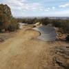
The far eastern part of the loop traverses an area of sandstone slickrock. The final couple miles of the trail are downhill and good fun.

 Continue with onX Maps
 Continue with Facebook


 Intermediate


 All Clear


0 Comments