Dogs Unknown

E-Bikes
Unknown
Overview
This ride combines
Wagonwheel Trail (168) and
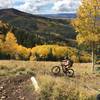
Bulldog Trail (5504) to make an enjoyable downhill adventure with only minimal uphill pedaling. It works best if shuttled - dropping riders off at the intersection of FR0087 and FR5247 and picking up at Devils Canyon Campground. Timing your visit to coincide with the brilliant fall colors is highly recommended.
Need to Know
Wear bright colors during hunting season. Trail can be muddy with deep pools.
Description
From just west of the intersection of FR0087 and FR5247, find the dirt road heading south through a large stand of huge aspens -
Wagonwheel Trail (168). This fun, twisting descent through the aspen glade is arguably the best part of the trail. Continue downhill through scrubby meadows and revel in the fall colors if you're lucky enough to time your visit just right. The trail surface doesn't have many roots, but can be covered in large, loose rocks in some sections. There are periodic views of nearby South Peak to the west. About 1/3 of the way along the
Wagonwheel Trail (168), you arrive at a junction with the
Wagon Wheel To FR0087 spur. Continue on Wagonwheel - straight and downhill to the southwest.
Begin a gentle climb through a more open area that can become quite boggy after a heavy rain. Some dismounting and bike schlepping may be necessary. After a brief traverse along a bench with sweeping eastward views, the trail gradient steepens and soon reaches Verdure Creek. Head up another short incline to reach the start of the
West Wagon Road Loop Trail. Continue south on the
Wagonwheel Trail passing through thickets teeming with nonchalant deer. The last part of the
Wagonwheel Trail (168) threads through a piney plateau with hardly any other ground vegetation.
At the junction of FR0084 and FR0085 (near the pit toilet), take a breather, then proceed a few hundred yards west along the main FR0084 road, keeping a sharp eye out for the first signed trail on the left. This will be the
Bulldog Trail (5504) (also called 5504) which branches off the 0084 fire road and heads south.
The descent is gentle at first, passing through wooded sections and occasional pretty aspen groves. Substantial erosion has gouged some biker-eating troughs in this trail. When not negotiating these tricky spots, the trail becomes more mellow and enjoyable, dropping at a steady gradient. The smoother sections are speedy and it is easy to lapse into a trance-like state as you whip through the dense forest.
Although there are fewer turn-offs and confusing trail junctions on this trail than others in this area, towards the bottom you need to be careful to stay on the right track. Some paths dead-end in campsites and others send you into the wrong drainage. A final short climb at the end brings you back to civilization with a bit of a view before the trail terminates at Alkali Pt. Road near the Devil's Canyon Campground.
Contacts
Shared By:
Megan W

 Continue with onX Maps
 Continue with Facebook


 Intermediate


 Abajo Loop: Spring Creek to Robertson Pasture

 Bikepacking: Moab to Boulder Town


0 Comments