
 Continue with onX Maps
 Continue with Facebook


 Difficult

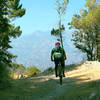
“A descent from Sunset Ridge Trail to Alta Loma Drive (an alternate route back to JPL parking). ”


1.5
Miles2.4
KMSingletrack
 Difficult
Local Club: Mount Wilson Bicycling Association
Land Manager: USFS - Angeles National Forest Office
 Ken Burton Loop
14.8 mi 23.7 km • 2,055' Up 626.5 m Up • 2,058' Down 627.35 m Down


 Mt. Lukens from the Fire Station
15.0 mi 24.1 km • 2,843' Up 866.4 m Up • 2,842' Down 866.24 m Down
Lukens/Grizzly Flat/Hoyt Mtn Loop
11.4 mi 18.3 km • 1,964' Up 598.57 m Up • 1,966' Down 599.29 m Down
Strawberry Peak Loop
15.6 mi 25.0 km • 2,593' Up 790.29 m Up • 2,603' Down 793.49 m Down
Altadena, CA
 Mt. Wilson Shuttle
6.9 mi 11.1 km • 193' Up 58.73 m Up • 4,876' Down 1486.28 m Down
Glendale Sports Complex - Cherry Canyon Loop
8.8 mi 14.2 km • 1,381' Up 420.81 m Up • 1,380' Down 420.61 m Down
La Caña…, CA


9 Comments