
 Continue with onX Maps
 Continue with Facebook


 Easy/Intermediate

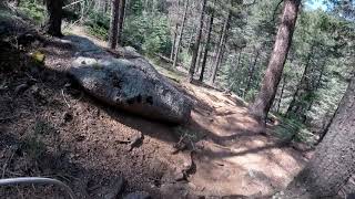
“A dirt road through the Pike's Peak Forest with access to many singletrack trails. ”


29.1
Miles46.9
KMDoubletrack
 Easy/Intermediate
Land Manager: USFS - Pike & San Isabel National Forests Office
 D-Loop #3
16.4 mi 26.4 km • 2,892' Up 881.61 m Up • 2,899' Down 883.6 m Down
 Chutes - Gold Camp Rd - Buckhorn - Captain Jack's
13.6 mi 21.9 km • 1,989' Up 606.1 m Up • 1,986' Down 605.45 m Down
 Colorad…, CO
 Roundup Trail Loop at Red Rock Canyon Open Space
3.5 mi 5.7 km • 432' Up 131.55 m Up • 439' Down 133.83 m Down
LPC After Work Ride
5.3 mi 8.5 km • 686' Up 209.09 m Up • 686' Down 209.23 m Down
 Ring the Peak
68.2 mi 109.7 km • 8,852' Up 2698.19 m Up • 8,853' Down 2698.31 m Down
Colorad…, CO
D-Loop #2.1
15.4 mi 24.7 km • 1,352' Up 412.11 m Up • 1,350' Down 411.42 m Down
Air For…, CO


 Bad / Closed


1 Comment