Dogs Leashed

E-Bikes
Unknown
Overview
This is an awesome, remote, extremely challenging loop on the edge of the Cohutta Mountains.
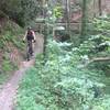
Near the start of the trail, you'll practically drop off the side of the Fort Mountain and the climb back up is also steep, rutted, with lots of loose baby-head rocks, and a couple of creek crossings. The trail is kept clear of large downed trees, but other natural debris (sticks, downed branches, and (gasp!) leaf litter) may be present as the trail doesn't get used as much as some other nearby trails. If that's not enough, it's common to find the trail criss-crossed with spider webs if nobody has taken clearance duty recently.
It might be the most difficult loop in Georgia, and it is at least among the more difficult trails in the southeastern US. Enjoy the sufferfest!
Need to Know
There is a $5 parking fee at the trailhead in addition to a $3 permit fee for each rider, or you can buy annual passes for parking ($50) and biking ($25) at all Georgia State Parks (2017 prices). Registration is required even if you have an annual pass. Since trails may be closed for maintenance or inclement weather, check with the Park Office to ensure availability.
Description
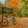
This trail starts out like any other north Georgia trail with some gently twisting singletrack through the forest with the occasional root obstacle. From the parking lot, follow the trail markers until you reach the outer loop. It's definitely recommended to run the trail in the clockwise direction so you descend the steepest part of the loop.
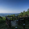
At about the 3.5-mile mark, you'll cross the park road and at four miles your blissful, gently twisting singletrack reaches the precipice. Take a moment to enjoy the view, drop your seat post if you don't have a dropper, and although you won't really need, it strap on any armor you may have brought.
The next mile is a 1,200-foot drop, most of it straight down a power-line cut, so get back behind the saddle you've just dropped and hold on! Beware as you near the bottom, the trail merges for a few hundred feet with a horse trail before continuing downhill. It is a little easy to end up on the bridle trail here, so watch for the sign showing the bike trail.
Once you've taken the plunge, the trail crosses a creek and rises gently mostly following old road beds for the next 2.5 miles to the area of an old mine. The trail again merges with the bridle trail at this point for 1,000 ft, so watch for 4-legged friends. The mine makes for a good place to take a break if you need one because there are a couple of picnic tables and there is a really awesome view of North Georgia...and because you've got some difficult climbing ahead.
It seems like a steep climb out of the mine, but that's a mere preview of what's to come. The next two miles return to the more typical North Georgia singletrack experience, including another mile long, 450-foot descent. A small part of this descent is shared with the bridle trail. There are several creek crossings in this section of the loop. Once this descent is complete, it's really time to pay the piper.
You'll climb about 1000 ft in the next mile and a half following Mill Creek. As if the steepness isn't enough, the trail is littered with debris including baby-head rocks and the climb features a number of switchbacks. As you near the top, there are a couple more creek crossings. The steep climbing doesn't finish until you've almost reached the right turn back to the parking lot at 12.8 miles.
From there, it's still 200 ft more climbing to the top, although the grade is not nearly as steep as what you've just completed. (Even if your tired legs are trying to tell you otherwise).
If you haven't found that sufficiently challenging, turn around and ride it in reverse.
History & Background
There's an old stone wall on top of the mountain that gives the park its name. Nobody really knows why the wall is there. There's also an observation tower on top of the mountain, but you'll have to leave the bike to get there. A number of mining sites round out the historical features of the park.
Contacts
Shared By:
Lost Justpastnowhere

 Continue with onX Maps
 Continue with Facebook


 Difficult

 Singlespeed Smackdown 2018

 Ellijay, GA
 Amadahy Trail
 Cohutta Death March
 Brush Creek


3 Comments