Dogs Unknown

E-Bikes
Unknown

Mountain bike permits are no longer required at Georgia State Parks. The $5 per car parking fee still applies if you park at the trailhead.
Description
Expect steep, moderately long climbs of about 2-3 minutes at times, and fast descents with some technical features.
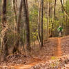
You'll start in the Smith Creek Bottoms day-use area. Follow the "bike trail" signs across the field and cross a bridge and immediately cross a gravel road. The trail only goes one direction (counter-clockwise). But it crisscrosses itself at the beginning.
After you cross the bridge and road, you'll climb up some doubletrack for about 50-100 feet, then bear left onto the trail (marked with blue blazes). You'll climb a switchback and then re-cross the doubletrack you just left (go straight to stay on the loop).
From here, you'll climb up through white pine forest with smooth trail tread punctuated by roots. Keep your eyes forward - about two miles in there is a really steep descent that you can come into with a lot of speed. It's not too technical, but keep your weight back and move to the right side for the best line.
You'll descend down and follow Smith Creek through a flood plain. Here, you'll intersect some doubletrack and turn right (or you could turn left and head straight back to your car). To stay on the loop, turn right, ride about one-tenth of a mile and turn right across a bridge. Pay attention as the trail veers to the left and up (you'll take the right side of the trail). This is the second part of the loop.
It's got more climbing and you'll ride through a lovely spray field (not lovely if you know what it is, but very green!). There are great, fast descents on doubletrack and singletrack. After a while, you'll come back to the bridge you crossed earlier. Turn left this time and follow the doubletrack all the way out past the funky old farm building and back to the Smith Creek Bottoms day-use area.
This is a fun trail - not worth driving two hours for, but if you're staying at Unicoi State Park, it's a solid option. It's particularly nice if you add in some great gravel riding for more miles.
Contacts
Shared By:
Daniel Jessee
with improvements
by Charlie Williams

 Continue with onX Maps
 Continue with Facebook


 Intermediate/Difficult


 Minor Issues


4 Comments