You came all the way out to the South Rim of the Grand Canyon National Park, but of course, there is no singletrack in the park open to bikes. The awesome Rainbow Rim Trail #10 is on National Forest land way over on the north rim. You owe it to yourself to do this section of the Arizona Trail with its singletrack which is just outside the park on National Forest land.
From east to west, it's a relatively easy, mostly downhill ride and likely you'll have more solitude compared to the hoard of tourists in the park proper, especially if you come outside the high season. You may even encounter some snow.
From the South Rim Village, ride east on Desert View Drive, or get someone to drop you off at Grandview Point. About a mile east of the Grandview Point access road, turn right onto
Coconino Rim Road/FS-310. In about a mile, you'll reach the Grandview Lookout Fire Tower. Park your bike at the bottom and climb up to the top of the tower to get a different view of the Grand Canyon and surrounding forest. The ranger at the bottom said it was OK as long as you don't go into the top of the tower, which is locked anyway.
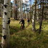
Passage 37 begins across the road from the tower towards the west. (Passage 36 continues to the east if you want to explore it too). The first third or so of Passage 37 is singletrack which weaves through a pine forest recovering from a recent forest fire and burn marks are apparent on the trees.
At mile 3.6 you'll encounter the most challenging feature of the ride which is a steep descent into a ravine, but most riders won't really have any issues with this. Once you get to Watson Tank (a small lake), the trail transitions to doubletrack most of the rest of the way to Tusayan. From about mile 12, you'll follow a (usually) dry wash to the outskirts of Tusayan. Just before Tusayan passage 37 turn towards the north to pass around the north side of town. It then crosses Arizona highway 64 (the main road into the Grand Canyon from the south) and follows the paved
Tusayan Greenway for about 2.5 miles.
Then the Arizona Trail leaves the greenway to the right crossing over the main park entrance road onto a section of doubletrack. This leads to the end of the trail at the South Kaibab Trailhead at the South Rim of the Grand Canyon.
Passage 38 continues across the canyon to the North Kaibab Trailhead. You are not allowed to ride this section but you can carry your bike: only 21.4 miles with about 5000 ft down and 6000 ft up.

 Continue with onX Maps
 Continue with Facebook


 Easy/Intermediate


0 Comments