Dogs Off-leash

E-Bikes
Unknown

This is a county maintained road with very low traffic.
Description
Hatton Ridge Road (CR-1228) splits off of
Spaas Creek Road and provides access to a few scattered parcels of private land mixed in with broad tracts of National Forest. It ends at Hatton Cemetery where the road is gated and turns into
FR 165, which is maintained by the USFS.
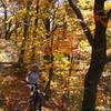
The area is almost completely undeveloped and the ridge is fun to ride and provides lots of possibilities for hiking and rock climbing. This would be a great area for bikepacking and just rambling around to explore.
Expect to see some off road vehicles, equestrians, and hunters in season.
Contacts
Shared By:
Chris Chaney

 Continue with onX Maps
 Continue with Facebook


 Easy/Intermediate


0 Comments