Dogs Leashed

E-Bikes
Unknown
Family Friendly
Several loops and terrain that's not overly difficult make this a good ride for kids, though you may want to shorten it.

Don't ride during spring freeze/thaw cycle.
Overview
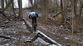
Nine miles of old school Michigan singletrack including many log piles and a few wooden bridges. Enjoy this great network of trails that have continued to increase in length and the fun factor over the last few years. It's actually one of Michigan's best-kept secrets.
Need to Know
The number one tip is to bring bug spray. Next, expect a number of log roll-overs along the way. Most have ride-arounds, but some don't.
Description
This ride offers a little of everything that you'll find in Michigan: tight, twisty singletrack through heavily-wooded areas, open doubletrack, sweet flowing segments with switchbacks, some interesting technical areas (log piles, bridges, rock garden, downhill with drop-offs) and a VERY fast downhill we call "Big Bertha". Of course, you could always ride it backwards and call it a BIG KICK BUTT climb!
The ride is considered moderately technical. There aren't many big climbs, but there are three short and steep ones with switchbacks all in a row. Also, there are some off-camber climbs as well as on the descents.
The trails dry out fast in the rain, and this is one of the first areas to be ready after the spring thaw. There's some sand, but things still hold up well even into the late summer. And the sections that aren't sandy are really fast and fun when summer dry spells have hit.
The full ride is nearly 11 miles in length, but it's possible to shorten things at many different points depending on your appetite for mileage and available time (it can seem a lot longer when you are riding it). New signage installed in 2016 makes it one of Michigan's best marked trails! Two trailhead kiosks, one at the Stubnitz Center and one in the soccer parking lot. Paper maps available at both.
Note that there is a section of trail behind the Stubnitz Center that is marked "No Bikes".
History & Background
The area was a family farm until the early 70's.
Contacts
Shared By:
Todd Blumerick

 Continue with onX Maps
 Continue with Facebook


 Intermediate

 4.5 (29)


8 Comments