Dogs Off-leash

E-Bikes
Unknown

Seasonal snow closures.
Overview
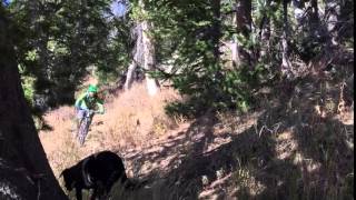
A climb and descent of the highest peak in the Wyoming Range. The ride consists of long sidecut switchbacks with high exposure, excellent grade, and high speeds in the vein of the
401 Trail in Crested Butte. Viewpoints abound the entire ride of the Wyoming Range and Grey's River Range. The summit offers an epic 360-degree panorama. Additionally, there is a rundown fire lookout at the summit.
The switchbacks are tight, and some loose, but the trail runs so long between switchbacks (at times a mile) that a respite from ripping is almost welcome. The trail is opened to motorcycles, but it doesn't seem like the trail see's a lot of these users due to technical difficulty. The summit register would suggest maybe 10-20 a year.
Need to Know
The FS road that leaves the Grey's River Rd. could be traveled by 4x4 vehicles as the clearance isn't too bad. However, the road is extremely rocky (loose) in places and seems more suitable to ATV's. Our party rode up the road and it is included in the map. With road included, the ascent is 4,000+ ft.
There is a much better (easier) access point from the Greys River Road that we discovered on our 3rd ascent/descent of Wyoming Peak in 2012. The link that I have provided documents this access point, as well as the ones that the OC documents here. I also have YouTube video of the descent (3 sections) see here:
hi-adventure.com/wyoming-pe…
If a rider only wanted to do the singletrack, then this alternate access point is much easier on a vehicle. You probably wouldn't even need a 4x4.
Description
Drive South on Grey's River Rd. FS 10138 to Kinney Crk. and FS Rd. 10128. At 10128, turn left and ride or drive this Rd. for ~3.5 miles and 1500 ft. At this point, the old logging rd traverses a large cirque. About halfway across this open cirque, the trail begins and is well-marked, on the left.
From here, the trail is obvious all the way to the summit, ascending the mountainside up long switchbacks on nice grade most of the way. There are a couple steep or exposed spots you may choose to walk, and the summit ridge is rarely steep and loose where you'll have to hike-a-bike. The final quarter mile to the summit is not really a great ride up or down. The only point to take your bike to the summit is that it feels good inside!
Contacts
Shared By:
Blaine Myers
with improvements
by Cody Feuz

 Continue with onX Maps
 Sign in with Facebook


 Difficult


0 Comments