Dogs Leashed

E-Bikes
Unknown
Overview
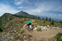
Windy Ridge Trail #167 is a beautiful stretch of singletrack located deep in the backcountry along the North Fork of the Clearwater River. The ride starts out in thick, lush, lower elevation forest along the river and ascends briskly up to beautiful sub-alpine forests and meadows which provide great views into the vast backcountry surrounding the North Fork.
Getting to this area can be a bit of a challenge in itself as it is miles away from any large towns and the only ways in are long, slow moving, winding roads. The rewards are well worth it, though, as the scenery in the area is wonderful.
Windy Ridge Trail #167 delivers miles of quality singletrack, and there are many more miles of trail open to bikes left to explore for the hearty adventurer.
Need to Know
There are many great camping options along the river, both paid campgrounds and dispersed camping areas.
Description
The ride to Cook Mountain begins at Fourth of July trailhead and pack bridge. Shortly after crossing the bridge, the trail wastes no time getting down to business and begins to climb fairly steeply, although not overly so, towards Bear Butte. The thick forest begins to open a bit as you ascend and nice views of the canyon and surrounding mountains start to become visible.
Once you reach the broad grassy ridgeline at Bear Butte Saddle, the trail flattens out a bit. It really starts to feel flowy as you roll through some more grassy meadows and then it will begin to descend towards Camp George. Exchange some high 5's and have a snack because the trail is about to climb steeply again. It will continue to ascend for about 3 more miles, but there will be flatter sections to help you catch your breath and also some nice places to take breaks.
Around nine miles in you'll come out on a broad sub-alpine ridge line; at this point the climb is more gentle and it continues along like this to Cook Mountain. There will be an unsigned junction at roughly 11 miles that you turn right onto the
Cook Mountain Spur (essentially, you're continuing straight) which leads to the top of Cook Mountain. There are great views from Cook Mountain, which was where an old fire lookout once stood. Take it all in and enjoy the open grassy meadows from the summit. During the middle of the summer, you might catch the Bear Grass blooming. This is where the out and back ride will turn around and it is a wonderful descent back down to the river.
It should be noted that from the junction with the
Cook Mountain Spur,
Windy Ridge Trail #167 does continue on. It will descend around 3 more miles to a junction with two other trails to explore or there is the option to continue on 8.8 more miles to the Lolo Trail jeep road.
Contacts
Shared By:
Kyle F

 Continue with onX Maps
 Continue with Facebook


 Difficult


0 Comments