
 Continue with onX Maps
 Continue with Facebook


 Difficult

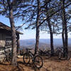
“An awesome descent off the tallest mountain in the George Washington National Forest. ”


15.5
Miles24.9
KMSingletrack
 Difficult
Local Club: Shenandoah Valley Bicycle Coalition
Feb 28, 2024: 30+ Years of Partnership at the Massanutten Western Slope
Feb 26, 2024: Action Alert – Safer Bicycling
Feb 17, 2024: The Future of the Western Slope
Land Manager: USFS - George Washington & Jefferson National Forests
 Southern Traverse - IMBA EPIC
36.4 mi 58.5 km • 3,946' Up 1202.66 m Up • 3,970' Down 1209.96 m Down

 Verona, VA
 Brushy Hollow, Stony Run & Fore Mountain North
19.1 mi 30.7 km • 2,771' Up 844.59 m Up • 2,818' Down 858.83 m Down
Clifton…, VA
Blue Suck Falls Loop
8.8 mi 14.2 km • 1,908' Up 581.47 m Up • 1,911' Down 582.45 m Down
Stokesville 60k
37.8 mi 60.9 km • 4,577' Up 1395.16 m Up • 4,586' Down 1397.87 m Down
Bridgew…, VA
TWOT: Camp Todd, Chestnut, Grindstone
18.5 mi 29.8 km • 3,490' Up 1063.71 m Up • 3,452' Down 1052.29 m Down
Narrowback Mountain Loop
15.2 mi 24.5 km • 1,490' Up 454.3 m Up • 1,480' Down 451.01 m Down
Dayton, VA


2 Comments