
 Continue with onX Maps
 Continue with Facebook


 Intermediate/Difficult

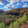
“This section is all wide doubletrack that dries quickly after rains. ”


10.3
Miles16.5
KMDoubletrack
 Intermediate/Difficult
Land Manager: USFS - George Washington and Jefferson National Forest
 Sherando Variety Pack
14.0 mi 22.5 km • 1,949' Up 593.95 m Up • 1,962' Down 597.9 m Down

 Stuarts…, VA
 Montgomery Hall Park trails
4.1 mi 6.7 km • 471' Up 143.49 m Up • 475' Down 144.83 m Down
Lookout Mountain from Stokesville
8.8 mi 14.2 km • 1,398' Up 426.26 m Up • 1,441' Down 439.36 m Down
Bridgew…, VA
Southern Traverse - IMBA EPIC
36.4 mi 58.5 km • 3,946' Up 1202.66 m Up • 3,970' Down 1209.96 m Down
Verona, VA
 James River State Park Complete Loop
14.0 mi 22.5 km • 1,531' Up 466.75 m Up • 1,532' Down 466.92 m Down
 RockStar TRAIL Route
282.3 mi 454.3 km • 29,125' Up 8877.4 m Up • 29,507' Down 8993.64 m Down
Harriso…, VA


0 Comments