
 Continue with onX Maps
 Continue with Facebook


 Easy
Easy


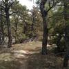
“A service road for the State Park that connects one side of the canyon to the other. ”


1.6
Miles2.5
KMDoubletrack


0 Comments