Dogs Leashed

E-Bikes
Unknown
Description
This trail forks right at the start; take the faint trail to the right. This is the original trail but after some tree felling blocked its path, it went unused for quite sometime and has just recently been cleared and reopened. This will wind you out to the gravel road around .7 miles. As you head north on the gravel section, you'll happen upon an intimidating gate. This is to prevent unauthorized vehicles from accessing the police gun range. Trail users have full permission to pass, there is a small opening just for us on the side. Do not feel anxious, zip on through and continue up the gravel road.
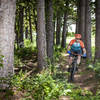
Once the gravel road begins to turn, you'll see the continuation of the trail marked. About 50 yards in you'll fork right and continue amazing singletrack. Almost 2 miles in you'll see a service road with some arrows - go right. You'll zip downhill and across some clearings that run along the lake. When the trail makes a strong left about 2.3 miles in, you'll see a very popular scenic view and great place for a break.
Continuing on you'll make it to one of the toughest, short climbs of the trail. Soon you'll see that same intersection you passed by earlier. When you do, take the service road to the right about 100 yards and you'll see the sign directing you to the right which leads into Sleepy Hollow, a favorite section of mine. In this area you'll find twisty track, open views, technical climbs, a hairy descent or two, and more wildlife than expected.
If you have been riding the Orange for several years or have an old map of the trail, you'll see the old entrance to the "Back 40" around the 4.5 mile mark. DO NOT ENTER. You can't enter by mistake; it's been barricaded with debris and trees. This area is now an active gun range, STAY OUT. You are completely safe on the trail as marked, but do NOT go west of the gravel road or its boundary line.
Returning back down the gravel, through the gate again, you'll see where you came out 6 miles ago. Turn back in and stay right, passing the trail you came in on originally. You'll see an old car that's been parked for some time. I don't think they have a permit now that I think about it. As you come in on this last leg, be mindful of hikers. This is a popular section of the trail for dog walkers and families.
Contacts
Shared By:
Ryan Souders

 Continue with onX Maps
 Continue with Facebook


 Intermediate

 4.3 (20)


 All Clear


0 Comments