Dogs No Dogs

E-Bikes
Not Allowed

No pets on the trail. Park charges a fee of $3 for daily use or you can pay $10 for an annual pass. Park closes at dusk so no night riding.
Overview
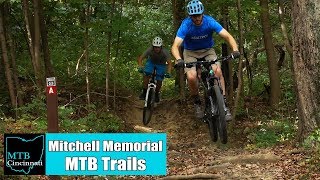
The trail is almost all singletrack and it is tight singletrack about shoulder width most of the time. The trail has very nice flow and some rock gardens mixed in. Both trails can be ridden in either direction.
Need to Know
Trail is subject to closures when the conditions are not good for riding (trail to wet, freeze thaw conditions). Do be careful we do have a lot of trail runners so watch out for them.
Description
The system is made up of 2 loops both about 4 miles long. We have an
A Loop and a
B Loop, with B being the more technical of the two.
About 0.4 miles in the
A Loop, you go over a small foundation that we incorporated into the trail. At the top of this short climb is a bailout but if you decide to stay on there are no more turns to worry about - just hammer on. After the frog pond there's a fun short downhill run across the only bridge on the system. After the split for the B loop, which is about 1.9 miles into the loop, the trail continues the fun with the best downhill run on either loop. The
A Loop contains all of the doubletrack in the entire trail system (about .04 miles total). You'll finish up across the street from the parking lot.
The
B Loop is the more technical trail due to the amount of rock in the trail surface. There is about a mile long on again off again rock garden that is very fun to ride and is probably my favorite section of the trail. Another fun part is the meadow section, which is very fast with great corners that setup nicely once you figure them out. This trail also has a nice tight switchback that can be tough if you do not hit it correctly.
There are no surprises on the trail so you can just get after it.
The
A Loop is normally ridden clockwise and the
B Loop was changed a few years ago. Now it connects to A loop at the 2.0 and 2.4 mile mark. So it is basically U now so the map here is not totally correct.
History & Background
Trail was built with all volunteer labor and all maintenance is done by the Cincinnati Off Road Alliance (CORA). The trail is 100% hand built.
Contacts
Shared By:
Troy Warnken

 Continue with onX Maps
 Sign in with Facebook


 Intermediate


 All Clear


2 Comments