
 Continue with onX Maps
 Continue with Facebook


 Difficult

“An out-and-back trail featuring a technical climb and flowy descent. ”


3.4
Miles5.4
KMSingletrack
 Difficult
Local Club: Rogue Valley Mountain Bike Association
 Mountain of the Rogue
7.0 mi 11.2 km • 1,323' Up 403.13 m Up • 1,315' Down 400.94 m Down

 Rogue R…, OR
 Sturgis Fork TH to Bigelow Overlook
3.7 mi 6.0 km • 805' Up 245.48 m Up • 805' Down 245.39 m Down
 Horse Springs Out-and-Back
5.8 mi 9.4 km • 1,141' Up 347.9 m Up • 1,142' Down 348.02 m Down
Jacksonville Forest Park
10.4 mi 16.7 km • 2,054' Up 626.16 m Up • 2,058' Down 627.15 m Down
Britt Woods
5.1 mi 8.2 km • 832' Up 253.45 m Up • 833' Down 254.01 m Down
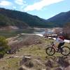
Applegate Lake
17.2 mi 27.6 km • 1,192' Up 363.27 m Up • 1,181' Down 360.06 m Down


1 Comment