
 Continue with onX Maps
 Continue with Facebook


 Intermediate/Difficult

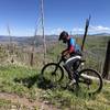
“A fairly difficult doubletrack that connects town to the Guaje Ridge Trail and Cabra. ”


2.5
Miles4.0
KMDoubletrack
 Intermediate/Difficult
Local Club: Los Alamos Singletrack Association
Land Manager: USFS - Santa Fe National Forest Office
 Los Alalmos Pipe Line Guaje
16.8 mi 27.1 km • 2,894' Up 882.04 m Up • 3,019' Down 920.09 m Down

 Half Aspen Loop around Pajarito Ski Area
5.0 mi 8.1 km • 1,195' Up 364.09 m Up • 1,195' Down 364.18 m Down

 Valles Caldera: Camino De Los Valles
35.7 mi 57.4 km • 1,616' Up 492.59 m Up • 1,615' Down 492.38 m Down
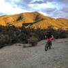
Los Alamos, NM
Winsor South Eight
15.4 mi 24.8 km • 2,705' Up 824.62 m Up • 2,712' Down 826.56 m Down
 Dale Ball Outer Limits
9.4 mi 15.2 km • 1,170' Up 356.64 m Up • 1,168' Down 356.01 m Down
Backdoor to Atalaya Mountain Views
5.6 mi 9.1 km • 911' Up 277.54 m Up • 988' Down 301.15 m Down


0 Comments