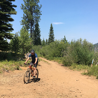
Gales Creek Trail is among the best cross-country trails in Tillamook State Forest. This long, challenging ride can provide a real sense of accomplishment, but it can also break the spirits of those less prepared.
It's a good idea to think of the trail as being split into two parts, divided by the summit at the Bell Camp Road Trailhead. The southern portion is a longer, more gradual climb up to the summit and the better part to ride. The northern section is much shorter, but also substantially more steep.
Starting from the southern trailhead at Gales Creek Campground, the trail follows its namesake for a number of miles up the valley. After only about three-quarters of a mile, the trail crosses a bridge and immediately T's at a junction. Heading left would start the steep, sinewy climb up the
Storey Burn Trail.
Turning right continues on Gales Creek Trail. The trail is often within sight or earshot of the creek as the singletrack winds along the ravines and gulleys that drain into Gales Creek. It makes for a lot of short, punchy climbs and brief flat stretches, always causing the legs to burn. It can feel rewarding nonetheless. Although not very technical for the most part, the ever-changing direction of the trail will keep you on your toes.
At about five-and-a-half miles, a short but super fun reroute of the trail brings some obvious MTB-inspired flow to the trail and is a blissful section... if only it was longer. The last half-mile is the steepest climb yet, but seeing the small parking lot for the Bell Camp Road Trailhead lets you know you're at the summit. This marks the end of the southern section of the trail.
Continuing north on the trail begins a very steep downhill as the trail loses all of the elevation it just gained in about half the distance. Unfortunately, it's not very fun riding. Much of the upper mile is almost straight down with few switchbacks. It begins to mellow out eventually and the bottom mile or so feels more like the first part of the trail.
The
Triple C Trail and
Step Creek Trail loops can be found at the northern end of this trail, but only the strongest riders will want to add these to their day, because that intense downhill must now be conquered in the opposite direction to get back. It's exhausting and brutal and might rob you of any sense of accomplishment for the ride. Many riders should consider just doing the
Gales Creek - Southern Climb. There's no shame in it.
The trail is well signed and easy to follow.

 Continue with onX Maps
 Continue with Facebook


 Intermediate/Difficult


4 Comments