Dogs Unknown

E-Bikes
Unknown
Description
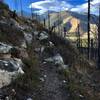
From the north, the trail passes out of the pine forests of Mt Elden into the cinder hills and open prairies of east Flagstaff. The most convenient trailhead on the north would be the Sandy Seep trailhead just north of Townsend Winona Rd. After Passing under the 89, the trail can be quite dusty and loose at points, which can be a bit demoralizing and squirly. After a bit, the trail drops steeply into picture canyon. This is the most technical section and many will walk here. After crossing the wooden bridge, immediately turn right.
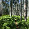
Soon you'll leave the pines into an open prairie. Right about this point you'll join a road heading East for about a hundred yards or so, which you'll quickly leave on the right hand side. After crossing the prairie, you'll parallel the train tracks for a while, mostly on singletrack. There is a dirt road that goes right next to the tracks - this is not the trail. There are a few confusing intersections of trails and dirt roads in this section.
If you keep your eye open for AZ trail signs it's not too hard to stay on track. After a bit, you'll make a hard right and head through tunnels under the train tracks and under I-40. After emerging from I-40, the trail heads back West for a few hundred yards before heading South. The next section heading south is quite beautiful with big views to be had both East and West. After a while, you'll cross Walnut Canyon Rd. and head West back into the pines.
This section of trail ends at the Old Walnut Canyon Trailhead, at which point you can head North to
Campbell Mesa and back to your car or continue Southwest to Fischer Point.
Contacts
Shared By:
Tyler Williams

 Continue with onX Maps
 Continue with Facebook


 Intermediate


0 Comments