Dogs Unknown

E-Bikes
Unknown
Description
Oly's trail is difficult in spots due to the rough bedrock you are riding on at times. It takes you back to the Beck Lake park canal bridge and the beginning of
Red Snake. The trail is named after an old sheep herder that used to walk to the high point of the trail every day to tend a flag he used to fly up there and do his best to sabotage the bike trail. Oly was outlived by the mountain bikers and this is a great technical downhill.
This trail is accessed from the top off the two track known as the
Red Light District. A BLM carsonite post marked with the number 11 is at the intersection of this trail and the two track along the ridge line. This is at the peak of the ridge as you climb from the South.
Follow the rock cairns along the first bit of trail as you dip up and down across the bedding planes of this ridge. At the highest point, veer left and begin heading downhill, watching for the trail that curves right. The trail prior to the curve to the right is only a couple hundred feet, but the trail is not very obvious due to the shale chips you are riding on. As the trail curls off to the right, stay off the brakes if you dare as you quickly get up to about 40 mph. The downhill is short, super fast and buff. After it bottoms out there are two rollers you hit that you can suck up or catch massive air off of. No matter how fast you go, you'll be faced with a quick punchy climb that takes you into the rocks of Oly's.
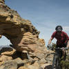
There are many ways down this rocky knob, but the most ridden line is towards the left edge. The trail is well defined after you pass through the big white rocks. The trail passes through a number of sections of bed rock connected by singletrack.
Oly's Trail is difficult. It takes you back to the canal bridge.
Contacts
Shared By:
John Gallagher

 Continue with onX Maps
 Continue with Facebook


 Difficult

 4.3 (4)


0 Comments