
 Continue with onX Maps
 Continue with Facebook


 Intermediate

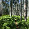
“Easy riding through pine forest with many possible connections. ”


6.8
Miles10.9
KMSingletrack
 Intermediate
Land Manager: USFS - Coconino National Forest Office
 Stagecoach Line 100 - 2022 Route
100.7 mi 162.1 km • 6,055' Up 1845.6 m Up • 6,786' Down 2068.33 m Down

 Schultz Pass Loop
11.5 mi 18.6 km • 926' Up 282.27 m Up • 931' Down 283.67 m Down
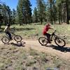
 Flagstaff, AZ
 'Round the Peaks
50.4 mi 81.2 km • 4,753' Up 1448.63 m Up • 4,753' Down 1448.78 m Down
Flagstaff, AZ
Schultz Creek 8 Ball
21.6 mi 34.8 km • 1,870' Up 569.86 m Up • 1,870' Down 569.85 m Down
Bikepacking: Craters and Cinder Cones Loop
183.1 mi 294.7 km • 8,329' Up 2538.8 m Up • 8,334' Down 2540.09 m Down
Cosnino Loop
14.5 mi 23.3 km • 913' Up 278.17 m Up • 909' Down 277 m Down


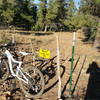


1 Comment