Dogs Leashed

E-Bikes
Unknown
Features
Views
Overview
This featured ride is meant to be done on a fat bike in the winter months. If you time it right, winter fat bike riding in FLNF is amazing. Frozen ground and packed snowmobile trails can be a great riding surface, and the lack of leaves on the forest trees exposes top notch views from the ridgeline. But you have to time it right with solid conditions…soft snow, deep snow, or unfrozen ground will make this ride unpleasant.
Need to Know
The Finger Lakes National Forest is an administrative unit of the Green Mountain National Forest. Both are managed by the Forest Service from offices in Rutland, Vermont, though the local Hector Ranger District oversees daily operations.
Finger Lakes National Forest - Hector Ranger Station
5218 NY Route 414, Hector, NY 14841
607-546-4470
Map -
cycle-cny.com/wp-content/up…
Map -
fs.usda.gov/Internet/FSE_DO…
Description
This featured ride is meant to be done on a fat bike in the winter months. It is extremely weather dependent. If you time it right, winter fat bike riding in FLNF is amazing. Don't ride this featured route unless the ground it totally frozen or the snowmobiles have packed the trails.
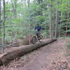
There are lots of ways to link the trails and dirt roads together within FLNF, and this featured ride covers most of the trails and many of the dirt roads open to bikes. Its a unique mix of doubletrack and dirt roads through fields and forest. In general, these trails are open to snowmobiles in the winter and equestrians during the summer. Most trails, roads, and intersections are well marked, but having a map, GPS device, or the
MTB Project mobile app is highly recommended.
The route starts at the Blueberry Patch Campground parking lot on Picnic Area Road. Catch the entrance to the
Burnt Hill Trail just east of the parking lot. Travel south on the
Burnt Hill Trail, taking in the grassland view as you cross over Matthews Road and eventually end at Burnt Hill Road. Turn north onto Burnt Hill Road and follow for approximately two miles.
Continue straight as Burnt Hill Road fades and becomes the
Backbone Trail. Continue straight north as the
Backbone Trail transitions back to dirt road and becomes Wardner Corners Road. At the next intersection with Searsburg Road, look northeast into the field for the start of the
No Tan Takto Trail.
Follow the
No Tan Takto Trail for approximately three miles, crossing open fields with expansive views, a couple roads, and a few forest patches. The
No Tan Takto Trail ends at a small parking lot on Parmenter Road.
Turn around in that parking lot and take the Interloken Trail back south. This two-mile long section of the Interloken Trail is the only section of this trail open to bikes. The Interloken Trail descends to a small creek, then climbs south as it connects back to Seneca Road near Teeter Pond. Turn east and pedal up Seneca Road for one mile, then turn south onto Vesa Road.
Follow Vesa Road south as it eventually fades and becomes a section of the
Backbone Trail. After traveling three miles south on Vesa Road and the
Backbone Trail, turn west through a field gate and continue following the
Backbone Trail west for another mile. Cross over Potomac Road and continue west on the
Backbone Trail for another mile until a T in the trail. Turn south and continue on the
Backbone Trail for another mile, eventually returning you to Picnic Area Road.
Turn east at the intersection onto Picnic Area Road and pedal up the hill to the Blueberry Patch Campground parking lot.
History & Background
The Finger Lakes National Forest lies on a ridge (called the "Backbone") between Seneca and Cayuga Lakes in the Finger Lakes region. New York’s only national forest, this multi-use land has a great deal of open land and free-ranging cattle. The forest has over 30 miles of interconnecting trails that traverse gorges, ravines, pastures and woodlands.
Native Americans lived in this part of New York for more than 10,000 years. The Iroquois are the last of the Indian tribes to have lived here, and Cayuga and Seneca Lakes honor their names. The land was divided up into "military lots" after the Revolutionary War, the one mile square units that are still the basis for the road (and much of the trail) system present on the Finger Lakes National Forest today.
The cellar holes, stone walls, artifacts, and other material evidence of the former residents of this area are an unwritten reminder and historical record of their lives. They are protected by Federal Law.
Contacts
Shared By:
Cycle - CNY

 Continue with onX Maps
 Continue with Facebook


 Intermediate


0 Comments