Dogs Leashed

E-Bikes
Not Allowed
Overview
Horsetooth Mountain is connected with Lory State Park offering many different route options. However, this ride stays strictly within the Horsetooth Mountain boundaries resulting in easy escape routes in case of bad weather or other emergency situations.
The park is mostly occupied by hikers climbing to the iconic horsetooth rocks or to the breathtaking falls, however hikers hardly ever use the biking trails featured in this route. The parking lot is large and contains a covered picnic area with a grill and water fountain. However, the grill is usually covered due to fire restrictions and the fountain's water is shut off during winter months.
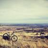
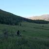
The ride is strictly fire road on the climbs and singletrack on the descents. The two fire road sections are steep, challenging, and rocky but amazing views are common place offering some much needed relief. The singletrack is fast and technical containing rocky drops, roots, and boulders. This route contains no hike-a-bike sections for experienced riders, but beginners may have trouble with a few parts. The long grass, skinny trail, and seemingly infinite number of pine trees offers an incredibly immersive Colorado experience perfect for anyone looking to take a break from their busy lives or out-of-state riders wondering what it's like to bike in Colorado.
This route (and all of Horsetooth Mountain trails) is NOT recommended for complete beginners. The climbs are long and difficult plus the singletrack is quite technical. However, intermediate bikers will have lots of fun, and riders looking to step up their game will not be disappointed.
Need to Know
The park's entrance fee is $9/vehicle. Do NOT park in the Horsetooth Lake Estates parking area which is located outside of the park (you'll know if you're parking here). It is VERY common to see cars ticketed and towed here.
Trails are clearly marked but there's only one permanent map on the trail so it would be helpful to take a paper map found in the parking lot or download the
MTB Project mobile app.
Cell phones have coverage on most parts of this ride (at least Verizon users have coverage).
Afternoon thunderstorms are NOT uncommon during Colorado's summer months. It is highly recommended to start the ride in the morning or to bring appropriate rain gear.
Rattlesnake sightings are rare but not unheard of so keep an eye out.
Description
The ride begins with a long, steady climb from the parking lot into the mountain. It's the only bike friendly trail that takes riders from the parking lot into the trees, so it's nearly impossible to miss. The entrance is on the west side of the lot and is easy to spot while driving in. It's called the
South Ridge Trail.
The first great place to take a break is at the top of the initial climb when the hiking trail meets with the fire road and the road takes a big turn into the trees. This spot offers a great view of Fort Collins as well as Horsetooth Reservoir.
Riders will bike for about a half mile after the break spot when they are confronted with a fork in the trail. Follow the
South Ridge Trail by taking the trail on the biker's left and continuing the climb. Do NOT go straight at this fork. If you see the entrance to the Horsetooth Rock Trail, you went the wrong way.
The climb will continue steadily for about another mile with great views of Fort Collins as well as neighboring mountains to the west. Eventually, you'll connect with the Horsetooth Rock Trail in a small flat area with a bench. This could serve as another great place to catch your breath and admire the views.
The final climb from the bench is definitely among the route's most difficult. It's very rocky and steep with roots and loose dirt. You'll likely need a few tries to clear this climb without falling off your bike. However, after summiting this, you've nearly made it to the top of the first major climb.
About a tenth of a mile from the gnarly climb, you'll make it to another fork in the road with the routes only permanent trail map. If you forgot a paper map, take a picture of this map or use the
MTB Project mobile app. After admiring the views, you'll take a right on
Wathen Trail and enjoy your first big descent. However, make sure you take another right soon after the first to stay on
Wathen Trail instead of ending up on the
West Ridge Trail.
At the base of
Wathen Trail, you'll meet up with
Spring Creek Trail in a beautiful valley. Make sure to make a left to begin climbing
Spring Creek Trail and then take a right on
Herrington Trail about a quarter mile up to eventually make it to the beginning of
Stout.
Stout is your second big downhill. It's the flowiest and fastest trail on the route.
Stay on
Stout until you make it to
Towers trail. Do NOT accidentally take a right half way through
Stout and go on
Spring Creek Trail. This section of
Spring Creek Trail is very sketchy and traverses a very steep part of the mountain.
Towers is the second and final fire road on the route. The view of
Towers initial climb from
Stout is very intimidating, but just keep pedaling, and you'll make it to the top eventually. Stay on
Towers until you make it to another flat area with a bench and a turn-off to the beginning of
Spring Creek Trail. This area is the last great place to catch your breath. Wild turkeys often walk through this area.
Spring Creek's downhill is the longest (and arguably most fun) of the three. Make sure to finish the descent at
Soderberg Connector Trail by taking a right. It's hard to miss but easy to mix up with
Wathen Trail. Make sure you turn off at
Soderberg Connector Trail. It will lead to a familiar part of
South Ridge Trail, and you'll finish your ride on this trail. There are a lot of drainage ditches that make great launch pads for jumping off.
Contacts
Shared By:
private account
with improvements
by Dan Matriccino
and 1 other

 Continue with onX Maps
 Continue with Facebook


 Difficult

 Ginny Trail via Powerline Trail


 Crosier Traverse
 Hall Ranch Intermediate Loop
 Pole Hill Road


 Minor Issues


2 Comments