Use onX Backcountry to explore the terrain in 3D, view recent satellite imagery, and more.
Now available in onX Backcountry Mobile apps!
For more information see this post.
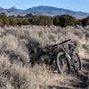
“A primitive road that winds down through pinyon pine on a ridge in Paine Basin.
”
If you enjoy Nanny Creek and Elk Canyon singletrack, this is another option down Paine Basin. It is all road but has a nice flow to it. Though there is no singletrack, it does have nice views of Elk Canyon and Nanny Creek.
The trail is accessed from the rest area by the same primitive roads used for Nanny Creek and Elk Canyon and is the first road to the right after Nanny Creek if you are coming from the summit rest area. The last 100 yards of the trail are rather steep. As the trail ends, you begin Upper Gutterball, then Ranch Bypass, and then Lower Gutterball. The trails are not well marked but every way down has been a bike trail at one time or another.
Moderately steep. Uneven terrain with small rocks or roots.
Sizable rocks & roots. Steep sections.
Steep. Some technical terrain and limited alternate lines.
Very steep. Technical terrain with no alternate lines.
Difficulty Rating
Average from 1 vote:
Intermediate
Your Rating
Virtual Tour of Elk Ridge
We use cookies to improve your browsing experience, to show you
personalized content, and for statistical purposes. By continuing
to navigate our website, you accept our use of cookies. Read our
Privacy Policy to learn more.

 Continue with onX Maps
 Continue with Facebook


 Intermediate


0 Comments