
 Continue with onX Maps
 Continue with Facebook


 Difficult

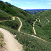
“Connects from Loma Linda Ridge Run to the top and bottom of Hidden Valley Ridge. ”


0.9
Miles1.4
KMSingletrack
 Difficult
Local Club: Hulda Crooks Homeschool MTB Club
Land Manager: City of Loma Linda - Public Works
 Crafton Hills
9.9 mi 16.0 km • 1,369' Up 417.34 m Up • 1,367' Down 416.75 m Down

 Southridge XC Course
5.8 mi 9.3 km • 710' Up 216.56 m Up • 708' Down 215.71 m Down
 NICA SoCal HS Cycling League: Beach to Boulders Race Course (2019)
5.7 mi 9.1 km • 421' Up 128.42 m Up • 423' Down 128.96 m Down
 Sugarpine Mountain Drop, North Side via Powerline Rd
10.6 mi 17.0 km • 2,155' Up 656.81 m Up • 2,155' Down 656.82 m Down
XC Training Route
7.2 mi 11.6 km • 1,876' Up 571.72 m Up • 1,874' Down 571.24 m Down
South Shore to Santa Ana Loop
27.7 mi 44.5 km • 4,549' Up 1386.46 m Up • 4,549' Down 1386.45 m Down


 All Clear


0 Comments