
 Continue with onX Maps
 Continue with Facebook


 Easy/Intermediate


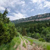
“An active forest road traveling south of the highway. ”


2.7
Miles4.3
KMDoubletrack
 Easy/Intermediate
Land Manager: USFS - Bighorn National Forest Office
 Muddy Canyon to Crazy Woman Canyon Loop
21.9 mi 35.2 km • 3,018' Up 919.89 m Up • 3,017' Down 919.72 m Down
 Clear Creek Trail
7.1 mi 11.4 km • 954' Up 290.78 m Up • 0' Down 0 m Down
 Buffalo, WY
 Bad Medicine Race: 90 Miles
93.3 mi 150.1 km • 9,851' Up 3002.46 m Up • 9,854' Down 3003.51 m Down
Greybull, WY
Bad Medicine Race: 56 Miles
58.7 mi 94.4 km • 6,103' Up 1860.31 m Up • 6,102' Down 1859.83 m Down
Greybull, WY


0 Comments