
 Continue with onX Maps
 Continue with Facebook


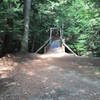
 Very Difficult

“A tough, tricky descent. ”


0.4
Miles0.7
KMSingletrack
 Very Difficult
Local Club: Sport Trails of the Ascutney Basin (STAB)
Land Manager: Town of West Windsor, VT
 Moody Park
6.0 mi 9.7 km • 491' Up 149.8 m Up • 491' Down 149.71 m Down

 French's Ledges
8.2 mi 13.2 km • 1,124' Up 342.55 m Up • 1,123' Down 342.36 m Down
 Boston Lot 3 Hills Ride
13.9 mi 22.3 km • 1,541' Up 469.74 m Up • 1,540' Down 469.41 m Down
Cascada
5.4 mi 8.7 km • 436' Up 132.93 m Up • 1,082' Down 329.77 m Down
Pittsfield, VT
The GMT Loop
14.3 mi 23.0 km • 1,769' Up 539.2 m Up • 1,769' Down 539.27 m Down
Pittsfield, VT


0 Comments