
 Continue with onX Maps
 Continue with Facebook


 Intermediate

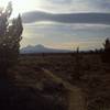
“A pretty trail along the river with the occasional technical rocky section. ”


2.2
Miles3.5
KMSingletrack
 Intermediate
Land Manager: Oregon State Parks - Smith Rock State Park
 Smith Rock Loop
7.9 mi 12.8 km • 1,314' Up 400.39 m Up • 1,313' Down 400.21 m Down
 Otter Bench Trail
6.8 mi 10.9 km • 353' Up 107.67 m Up • 352' Down 107.27 m Down
 Culver, OR
 Maston Inner Loop
7.9 mi 12.7 km • 251' Up 76.5 m Up • 251' Down 76.58 m Down
Redmond, OR
Kent's-Phil's Loop
5.6 mi 9.0 km • 367' Up 111.74 m Up • 368' Down 112.31 m Down
Bend, OR
Mrazek, Farewell, Skyliner, Whoops, Phil's Loop
31.1 mi 50.0 km • 2,574' Up 784.54 m Up • 2,687' Down 818.92 m Down
Swampy to Mrazek
26.3 mi 42.3 km • 1,608' Up 490.13 m Up • 3,748' Down 1142.34 m Down
Deschut…, OR


0 Comments