Dogs Leashed

E-Bikes
Unknown
Description
Summit Adventure Trail...it will definitely be an adventure to anyone who dares venture to this summit! It is some of the toughest riding you'll find on the front range. It is also a beautiful trail!
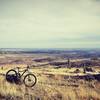
The trail begins from a large parking lot off of Hwy 34 in the Big Thompson Canyon. Leading out of the west end of the lot is a fire road climbing up a significant grade. It wraps around the hill to the left and levels out. Here, the trail splits. There is a large sign pointing out your options.
The Nature Trail continues straight (or to the right) and the Summit Trail breaks to the left. Following the Summit Trail, it continues as a fire road, but the grade gets steeper and here there are small loose rocks to contend with. This steep fire road climb lasts for about 100 yards until at the top of it the trail finally levels out and becomes singletrack.
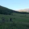
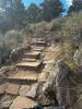
The singletrack heads east at a modest grade, hanging to the side of the mountain with a non-trivial amount of exposure to your left. There are only a few rock outcropping obstacles before it begins to gain elevation again in earnest. Now and for the next ~two miles the trail is very techy and very steep. With big rocks, tight switchbacks, scree fields and steep grades, the trail will have you questioning whether bringing a bike here was really a good idea.
Push through it, though, and you'll be rewarded with mile three, where the grade levels out and may even lose a little elevation. But, lest you think that mile three will be easy, the tech level goes up...way up. The unrelenting rocks and big moves finally spit you out into a nice aspen grove where the trail finally becomes actually pretty nice, almost loamy.
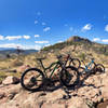
Beginning around mile four to the end, the trail regains its steep grade. This may be the steepest part of the trail. However, most of the techy spots are behind you. Trudge your way up the steep grades and tight switchbacks and you'll eventually emerge at the summit, a summit that you would probably never even notice if not for the giant rock cairn which has been built there.
The forested summit doesn't offer much in terms of views or grandeur, but you're going to feel like a champion if you can make it there with your bike. All said for me, in the uphill direction, this trail was about 60% ride and 40% hike-a-bike.
Turn around and retrace your steps back down the mountain; it'll be a long and bumpy ride! In the downhill for me, this trail was about 90% ride and 10% hike-a-bike.
Contacts
Shared By:
Jared Crockett

 Continue with onX Maps
 Continue with Facebook


 Very Difficult


0 Comments