
 Continue with onX Maps
 Continue with Facebook


 Difficult

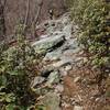
“Half Forest Service road, half steep singletrack. ”


3.3
Miles5.4
KMSingletrack
 Difficult
Land Manager: USFS - George Washington & Jefferson National Forests
 Seven Bends State Park with Woodstock South Ridge
12.9 mi 20.8 km • 1,996' Up 608.5 m Up • 1,991' Down 606.91 m Down


 The Massanutten Ring
69.5 mi 111.8 km • 8,638' Up 2632.88 m Up • 8,633' Down 2631.39 m Down
Strasburg, VA
Signal Knob - Meneka Peak - Bear Wallow Loop
8.7 mi 14.1 km • 1,752' Up 533.86 m Up • 1,746' Down 532.32 m Down
 Beginner Ride
6.9 mi 11.2 km • 466' Up 142.07 m Up • 470' Down 143.21 m Down
 Bird Knob and Catherine Furnace Loop
20.2 mi 32.5 km • 3,580' Up 1091.13 m Up • 3,581' Down 1091.51 m Down
Northern Traverse
33.5 mi 53.9 km • 3,864' Up 1177.62 m Up • 3,856' Down 1175.32 m Down


0 Comments