
 Continue with onX Maps
 Continue with Facebook


 Difficult

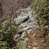
“A long section of rocky singletrack with tough climbs and great downhills. ”


7.7
Miles12.3
KMSingletrack
 Difficult
Land Manager: USFS - George Washington & Jefferson National Forests
 Big Schloss Loop
9.6 mi 15.5 km • 1,658' Up 505.41 m Up • 1,644' Down 501.16 m Down

 The Massanutten Ring
69.5 mi 111.8 km • 8,638' Up 2632.88 m Up • 8,633' Down 2631.39 m Down
 Strasburg, VA
Elizabeth Furnace - Figure 8 of Hate
Strasburg, VA
Elizabeth Furnace - Figure 8 of Hate
24.4 mi 39.2 km • 2,975' Up 906.74 m Up • 2,972' Down 905.87 m Down
Duncan Hollow
12.5 mi 20.1 km • 1,577' Up 480.58 m Up • 1,620' Down 493.89 m Down
 Beginner Ride
6.9 mi 11.2 km • 466' Up 142.07 m Up • 470' Down 143.21 m Down
Northern Traverse
33.5 mi 53.9 km • 3,864' Up 1177.62 m Up • 3,856' Down 1175.32 m Down


0 Comments