
 Continue with onX Maps
 Continue with Facebook


 Intermediate


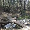
“A wide dirt road alongside a canal from Calimesa Blvd, which turns into gravel path and gets steeper past Yucaipa Blvd. ”


4.5
Miles7.2
KMDoubletrack


0 Comments