Dogs Unknown

E-Bikes
Unknown
Description
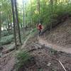
This is another trail where less experienced riders can develop their skills. Corners are tighter than on the other trails in the area and negotiating between trees is required. The inner loop has several log piles to ride over that can be intimidating to beginners at first, but are navigable. On a couple of logs, the large chainring may hit the top log (depending on frame and wheel size), but this is a great place to learn how to surmount obstacles. There are a few short downhills and associated uphills that challenge beginners.
For the most part the trail is flat, but it has enough elevation changes and whoop-de-dos to make it fun to ride. The trail designers have made good use of the gullies that run through the woods. The trail dries slowly after a rain and is the last to open in the spring.
The trail is in the south east corner of the intersection of McCormick Road and Cherry Lane next to one of the Purdue golf courses. From the corner of McCormick Road and Cherry Lane, proceed east on Cherry Lane and the trailhead is on the right. From Northwestern Ave, proceed west on Cherry Lane past the Purdue golf courses and the trailhead in on the left.
Park in the gravel pull off on the south side of Cherry Ln. Enter the woods and take the trail farthest to the right. Follow the winding path to the south end of the woods along the boundary with the golf course, then wind back around until you see a bridge straight ahead. To complete the full loop, turn right before crossing the bridge, or take the bridge for a shortcut back to the car.
This trail used to be divided into an inner and outer loop, but with the increased erosion around the valley through the middle of the woods, most of the bridges have been removed and new connector trails have been added to keep most of the trail in use.
Contacts
Shared By:
Brian Schoolcraft

 Continue with onX Maps
 Continue with Facebook


 Intermediate


0 Comments