The Garden Gate trailhead is about two miles west of Drake along the south side of Hwy 43. It's a small trailhead with room for six to eight vehicles and no restrooms.
Access the trail through a small gate which takes you up a small stepped hill to the right. At the top of this hill is a sign of the area, including a trail map for the mountain.
Beyond this sign, the trail meanders through a wide open meadow, sometimes full of wildflowers, with expansive views of the river valley. It is very beautiful, and the climb through the meadow isn't too hard.
As you get towards the top of the meadow and enter the forest, you might start to feel like you've got this all under control. The fun and flow of the trail continues for the first 1/4 mile or so under the canopy of the forest. Then suddenly, the personality of this trail changes drastically!
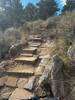
The grade becomes crazy steep, and the rock obstacles become crazy big. There's a lot of hike-a-bike along this trail, even on the descent back down; there are stretches of this trail that should not be attempted except by the truly expert rider.
The frustrating part of it is that there are several long stretches of this trail that are truly amazing. Around the middle of the trail is a very large mountain meadow that is very picturesque. The trail grade here is mellow and the flow is great in either direction and especially downhill. Beyond the meadow, however, get ready for more steep grades and big rocks. Again near the top, the grade mellows and the riding is great.
This trail can be used to access the summit of the mountain, where spectacular views await. Near the top is an intersection with the summit spur,
Crosier Mountain Summit Trail (#931-1) - a steep ~1/2 mile climb - and the
Crosier Mountain Glen Haven Trail (#931-2), which can be used to ride down into the town of Glen Haven.
This trail doesn't see a whole lot of traffic, which is another part of the allure. The most traffic it gets is from pedestrians, and rightfully so. It's a great trail to run and hike on, tougher for those on two wheels.

 Continue with onX Maps
 Continue with Facebook


 Very Difficult


4 Comments