
 Continue with onX Maps
 Continue with Facebook


 Difficult

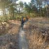
“This trail starts on a difficult climb but becomes much easier after going over the top of the hill. ”


1.2
Miles1.9
KMSingletrack
 Difficult
Local Club: Quiet Corner NEMBA
Land Manager: Connecticut DEEP
 Pachaug State Forest Loop
13.8 mi 22.3 km • 1,142' Up 348.13 m Up • 1,159' Down 353.14 m Down


 Mooween State Park
11.4 mi 18.4 km • 787' Up 239.84 m Up • 790' Down 240.74 m Down
Colchester, CT
Big River Park & Ride - Carr Pond Loop
10.0 mi 16.1 km • 579' Up 176.62 m Up • 580' Down 176.74 m Down
West Wa…, RI


0 Comments